
MARCH Meeting 2017
Mike Freeman from the WA Department of Mines and Petroleum displayed his passion for geoscience education when he enlightened us about six of recognised impact structures in Western Australia.
15 of Australia’s 33 confirmed and probable impact structures are located in WA. Of these, only four are craters and there is one ‘sloppy’ remnant. Nine are exposed but eroded or structurally affected by later tectonics, three are deeply eroded and three are buried in sedimentary basins.
Characteristics use to distinguish impact craters from other geological structures include:
- Macro-scale characteristics:
- Ring syncline/anticline couplet
- Central rebound uplift
- Micro-meso scale characteristics:
- Meteorite fragments
- Shatter cones
- Planar deformation fabrics
- Thermal alteration
- Vesicular glass and suevite (a rock consisting partly of melted material, typically forming a breccia containing glass and crystal or lithic fragments)
- Pervasive silicified and intensely fractured with microcrystalline quartz infilling fractures
At 24m across and 3m deep, the Dalgaranga crater located 60km from Cue is WA’s smallest and also youngest crater. The landform suggests the impact occurred as little as 3000 years ago. The crater size suggests a meteorite of around 1 tonne. Unfortunately many of the mesosiderite (stony irons) fragments have been lost since the crater was found in 1924 by a stockman herding sheep. The Shire of Yalgoo has developed the site as a tourist attraction.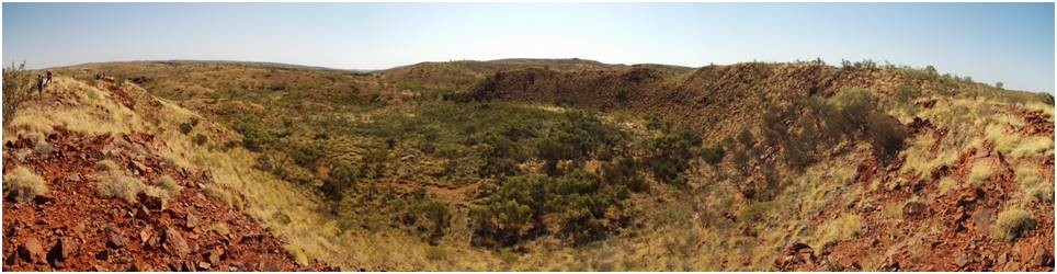
The 270m wide Hickman crater (north of Newman) is partly infilled with alluvium but still measures 30m from crest of rim to floor. A core hole drilled by Atlas Iron on behalf of the GSWA in 2011 in the centre of the crater found 48.4m of alluvium and 6.7m of suevite above the shattered basement. The date of the impact is currently unknown.
Wolfe Creek crater in the Tanami Desert is the second largest impact crater in the world. It measures 880m across. Gravity measurements suggest between 120m and 320m of fill, some of which is likely to be ejected material which fell back into the crater. Analysis and dating of remnants indicate an iron meteorite travelling from the northeast impacted around 300,000 years ago.
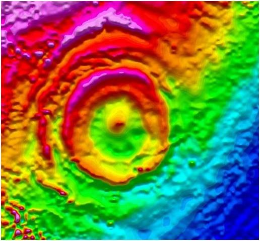 About 200km north of Perth near Badgingarra a broad shallow depression with little suggestion of impact is the only indication of the buried Yallalie impact feature. Magnetic images of Yallalie and the surrounding area shows concentric rings of magnetic highs and lows centred on a high. Seismic sections also show circular disturbed bedding in Cretaceous sediments extending 2km from the centre. Today Yallalie is interpreted to have been formed in the same way as the Yuty crater on Mars; a meteorite hit a shallow sea where unconsolidated sediments flowed outwards, producing waves of diamictite (a poorly sorted or non-sorted terrigenous non-calcareous sedimentary rock that contains variously sized clasts from clay to boulders in a muddy matrix).
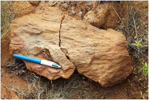
The Yarrabubba crater (east of Meekatharra) is a deeply eroded impact site. It is at least 30km across but magnetics suggest over 50km. Outcrops of granite with shatter cones up to 50cm and multiple deformation planes in quartz; indisputable evidence of impact. The Barlangi Granophyes is a hill of the molten pool of rock formed in the impact. Regional geological interpretations suggest the meteorite impact occurred between 2200 million years ago and 1500 million years ago.
 Following the untimely death of American meteorite guru Gene Shoemaker in a car accident on the Tanami Track in 1997, the Teague Ring was renamed the Shoemaker Impact Structure (north east of Wiluna.) The inner syncline is about 20km across while the outer anticline is 26km across. In addition to the large ring structure, the crater and the rocks display many of the characteristics listed at the beginning, particularly the presence of shatter cones, planar deformation fabrics and a central rebound structure. The age of the impact has not been determined but it must be younger than the 1880 million year old zircons found in the overlying volcanic rocks.
Mike believes there are more impact craters to be found in WA. However the deeply weathered surficial cover means we will need to keep using remote sensing to locate them (magnetics, gravity, vague topographic features).
Don Poynton
Note: there is a map on this web site: www.museum.wa.gov.au/sites/default/files/Met-FT-2012.pdf