
Our meeting entitled “Papua New Guinea experiences” was a dual presentation by two of our local members, both keen nature observers and both having spent time in the country for different reasons, albeit forty years apart.
Eric McCrum related some of his experiences working as a patrol officer and local government adviser in the late 1960s. His area, in the Tamata and Oro Bay Districts, covered 170 villages in the north (~8oN) of New Guinea (NG). His work was within typical rain forest and hilly countryside that included Mount Lamington at 1680 m, an active volcano. Eric and his family were based firstly at Kokoda and then in Popondetta. The nearby Kokoda Track, maintained by the Australian Army, is the well-known 96 km unmade pathway between Kokoda and Sogeri across the Owen Stanley Ranges making a spine of New Guinea.
Eric’s illustrated talk showed us scenes of typical village community life, the houses built from locally gleaned materials, on stilts with roofs of sago palm leaves tied to timber struts. Smoke from cooking fires exits through the palm roofs. Although of flimsy appearance these houses withstood the constant heavy rains that could be as much as 5 m in a three month period. The local children roam almost naked, or clad in banana-leaf skirts but do dress for school and are required to work after school time, slashing grass and sweeping the school areas. By contrast, at special meets the local adults, their faces painted, were shown in their special and elaborate ceremonial dress of feathered headgear decorated with hornbill heads.
Free-ranging pigs and chickens are part of village life. Butterflies, a yellow python, dragon lizards, beetles, spiders and a cuscus 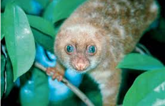 were among the slides illustrating the local fauna, against a luxuriant floral backdrop. Eric emphasised that all creatures found locally were potential food and because of this bird calls were heard only in more distant or less populated areas. Birds-of-paradise mostly recognized from their calls, including the raggiana and 12-wire types, were seen but were rarely observed because of their scarcity and the difficulty of seeing them in the forests. Other photographs included the beautiful ground-dwelling Victoria Crowned Pigeon (Goura victoria), hornbills , and red-bellied frogs.
Land ownership is vested in the local inhabitants, and Government agents purchase land for roads, and timber for projects, by negotiation with the local peoples. Apart from subsistence agriculture both cocoa and coffee (Arabica and Robusta varieties) are grown as cash crops.
Rob Anderson, our second presenter, began with a cautionary note on some of the social problems in PNG, including attacks that are not uncommon. Rob’s experiences, on work related projects, covered recent visits in the southern part of the southern highlands areas including: Hides (near Tari), Komo, Moro (Lake Kutubu), Gobe, Kopi and Kikori. Like Eric, Rob also emphasised the attractive natural history of the various areas where he was working.
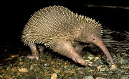
Rob also recounted that he had met up with Jared Diamond, the well-known geographer and author. It was Jared Diamond’s contention that the natural health of an area can be judged by its birdlife and that PNG represents the best rain forest areas on our planet. Some of his work (JD) established 70 recorded bird calls in an area, heard in the very early mornings starting almost in the dark at 0430. Taking us on an excursion, altitude related, Rob told us he has seen several birds-of- paradise (at approx. 600 m altitude) and a notable sighting of a long-nosed echidna, considered to be extinct.  At 1300 m, a crab was on view crossing a track and at 1400 m fossilised shell lithology was evidence of a recent geological uplift (7 Ma event) of marine sediments. Rainfall between July and September is recorded at between 56 and 72 inches per month. The obvious effect of the heavy rains is the common flooding of tracks, fast-flowing rivers with rapids and waterfalls (requiring ferries/and or bridges), and access though the countryside is generally poor. Technological projects, specifically the gas and oil pipeline construction of several hundreds of kilometres, proceeds in spite of major engineering challenges with the terrain and rain. Work camps and access to projects in the middle southern highlands is facilitated by helicopter.
Rob’s photographs, taken only opportunistically when a camera was to hand, included a range of butterflies, a land crab, large land lizard (Varanus salvadorii), cane toads, horny stick insect and many scenic ones including river views, steep local limestone topography also showing a recent landslide, ferry crossings, a grave site on the pipeline, Lake Kutubu (a volcanic lake) and the river-ridden region around the Gulf of Papua. His photographs demonstrated not only the attractiveness and general inaccessibility of the countryside, but also the challenging environment for building a pipeline.
Both presenters brought along examples of artwork, craftwork and weapons, all made of local PNG materials. Among the unusual items were a wooden pronged bird catcher, a killing stick armed with the carved and barbed shin bone of a cassowary, a palm bow with bamboo string, ‘dillum’ basket/bags, woven from fibre of the rolled aerial roots of the pandanus palm (these are used to carry vegetables with the handle worn over the brow), a large carved wooden story board (recording notable events), a boar’s tusk and bead necklace, and a ceremonial Kina shell* head band/necklace.
There was also a hand specimen of the 7 Ma fossil shell limestone.

Both our presenters emphasised the richness of the natural environment and it seemed that little had changed in the forty year period between their two visits.
Susan Stocklmayer
* Pinctada maxima, known as Kina shell, is a large mother-of-pearl oyster shell from which the PNG currency takes its name.
Reference recommended (by RA) Beehler, Pratt, & Zimmerman. 1986 “Birds of New Guinea”, Princeton University Press.